- Home
- About
- News
- Membership
- Resources
- Events
- Contact
- Find a Trail
American Tobacco Trail - Massey Chapel Road to Morrisville Parkway
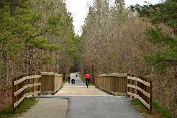
Overview: This part of the American Tobacco Trail gives you two possible directions at the start. In one direction is a mile of primitive trail that sends the adventurous walker through woods not far from some apartment complexes. (this short out and back section is not maintained by Durham or the trails conservancy but a portion of it will be part of the 2012-13 construction to complete the Durham portion of the ATT). In the other direction a well-maintained dirt trail leads to Chatham County where the trail changes to a much wider dual surface trail with asphalt and adjacent granite screenings giving you a choice of a firm or softer surface. Traveling in this direction takes you through forest for about 2 miles before you reach the Chatham County line. The smooth transition from primitive to developed is one highlight of this section. While on the trail, you will notice a transition from urban to rural that mirrors the transition of more to less populated sections. Right after entering Chatham you will cross New Hope Creek, and perhaps a mile more brings you to a trail crossing at O’Kelly Chapel Road. About .8 mile further brings you to Pittard-Sears Road and then to a second bridge, this one spanning Panther Creek. In another 1.3 miles you will cross New Hope Church Road, the final trailhead in Chatham County. The change in scenery also highlights the different forms that the American Tobacco trail undertakes.
Trail Information: The American Tobacco Trail at the Massey Chapel Road entrance may seem a little complicated to newcomers in that it offers two very different experiences. You can either head towards a one-mile dead end or a fourteen-mile stretch. If you are looking to go off the beaten path, head towards the dead end. You travel down a somewhat narrow but navigable two-foot-wide lane. Not many people use this side of the trail so you may have it all to yourself. This side of the trail is ideal for mountain biking, catching a scenic view of a man-made pond, archery hunting or walking to the dog park at the dead end. This part of the trail feels quite remote, though you’re actually just a short walk from residential neighborhoods.
The other side of Massey Chapel Road is smooth and level. (NOTE: As of early June 2012 the section from Massey Chapel to the Chatham County line will be closed for ~1 year due to construction that will bring a 10’ wide asphalt surface where there is now a dirt trail). While the trail itself feels quite rural, you’ll likely find many other trail users at this popular spot. This section of the trail is surrounded by private property rather than public land; you’ll be warned frequently not to trespass by leaving the trail. However, there are opportunities to leave the trail where it passes by suburban neighborhoods or public parks. Overall, this part of the trail has fewer amenities than the more urban parts of the American Tobacco Trail. About 300 yards north of the crossing with Scott-King Road you will see signs pointing to Herndon Park on the right. Taking the new cement connector path you will find restrooms and water (open seasonally from late March to early November). From that building you can quickly return to the ATT via the connector or take the Park exit road to Scott-King and rejoin the trail. Mile markers occur every half mile, and there are currently no nearby shops or places to stop for water or food, so come prepared with sunscreen, water and anything else you might need for your time on the trail.
This long stretch of the American Tobacco Trail will take you through a number of different landscapes and path materials, ranging from gravel to sand or dirt. The open grasslands and forests that mark much of this part of the trail give way to the modern world when you hit the paved trail in Chatham County about .7 of a mile south of Scott-King. This part of the path stretches 4.7 miles and expands to accommodate increased demand in this area. Much of the Chatham County section has a 6’ wide soft surface adjoining the 10’ paved section. Those seeking a flat, level terrain for walking, running or cycling will especially enjoy the Chatham County stretch. Benches are located ~ every half-mile, and there are a number of trash cans along the trail to allow users to help keep the trail clean.
Parking and Directions: To get to Massey Chapel Road from Chapel Hill, make a right onto Barbee Chapel Road from 54 Hwy. East. This road turns into Farrington Road. Soon afterwards, make a right onto Stagecoach Road. At the end of Stagecoach Road turn left onto Highway 751 North. Massey Chapel Road is the first right. A quarter-mile down the road there are two entrances for the American Tobacco Trail. Parking is allowed along the road by the ATT entrance. Parking is also available at the Fayetteville Road access point across from New Hope Church (7619 Fayetteville Rd, Durham, NC 27713) and at C.M. Herndon Park (511 Scott King Road 27713). Further south roadside parking near the ATT crossing at O’Kelly Chapel is prohibited. As of May 2012 parking at the Pittard-Sears crossing is limited to 6 vehicles. By the Fall of 2012 parking for ~16 vehicles should be available at the Pittard-Sears access.

Donate Now!
NCRT appreciates your support!
If you'd like to become a NCRT member and receive occasional updates from us
Support NCRT

North Carolina Rail-Trails is a proud member of Earth Share of North Carolina. Look for us in your workplace giving campaign.


